

“Caring for the planet is vital for our survival.” (World Environment Day)
In this first full week of June, we’re celebrating World Bicycle Day (June 3rd), World Environment Day (June 5th), and World Oceans Day (June 8th).
Luckily, our general focus on environmental problems increases. In honor of the environmental awareness this week, we decided to dig into one of our favorite products, Google Maps, and show you how navigation makes it easier for all of us to lower our carbon footprint.
Discover bike-friendly routes
If you live within cycling distance of your work, school, or wherever you’re heading, you can use the web application to get an overview of bike-friendly routes. Open Google Maps with nothing entered in the search field, click on the menu button at the top left corner, and choose “bicycling”. This will bring up a map marked specifically for cyclists. This is especially useful if you live in a big city or recently moved to a new neighborhood. Who knows, maybe you’ll discover a time saving shortcut or a picturesque area.
Of course, you can also get bike-friendly directions on your phone. Just open your Google Maps app, type in your destination, click “Directions”, and you’ll get the possibility to choose between directions for either driving, public transportation, bicycling, or walking right underneath the destination field.
Take control of your commute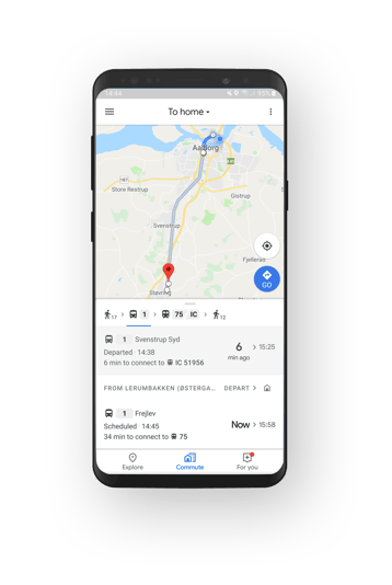
Honestly, I’ve never been a big fan of commutes. Being stuck in a hot, crowded tube, waiting for delayed busses, or running to catch the train really stresses me out, but with the commute tab in Google Maps, commuting is suddenly not that stressful anymore.
The commute tab gives you on-tap access to live traffic and transit information tailored to your commute. Just hit the commute tab in the bottom of the Map and Google will tell you if your commute is going to be a normal one or if you’ll need to budget extra time due to things like an accident or heavy traffic. In case of delays, Google also suggest alternative routes and Android users will even get notifications about delays and disruptions on their route as they happen.
If your commute involves both walking, driving, and public transit, Google provides you with helpful information about when to leave, and for each leg of your trip, you’ll know if there’s traffic on your drive, when the next train departs, and how long it’ll take to walk from the train station to the office.
Missing a bus is annoying, but so is waiting for a delayed bus. Transit riders in 80 regions worldwide can see exactly where their bus or train is in real time on the map. In Sydney, Google has even partnered with Transport New South Wales to show people how full the next bus or train is. This feature will be coming to more cities around the globe soon.
Ridesharing is caring
Passenger cars are a major polluter, accounting for 60.7% of the total CO2 emissions from road transport in Europe, but it doesn’t have to be like this. Actually, modern cars could be among the cleanest modes of transport if shared, rather being driven alone.
As much as I’d love to take my bike or a train to work every morning, it’s just not possible. Getting two kids, aged 3 and 4, and myself ready takes time, and while driving to work takes me about 15 minutes, going by bike would take me a little more than an hour and public transportation would make travel time even longer than that. But, as mentioned, modern cars could be among the cleanest modes of transport if shared, and it’s cheaper when you carpool with colleagues or others who are heading in the same direction as you.
In addition to carpooling, there are a number of ridesharing services that offer you cheaper and more eco friendly transportation and you can even earn a little extra by signing up as a driver. Did you know that a lot of the ridesharing apps such as Uber, car2go, GoMore, and DriveNow, are built with Google Maps APIs?
Explore the world with Street View
Emissions from aviation accounts for approx 3% of the EU’s total greenhouse gas emissions and more than 2 % of global emissions. But, there is a way to discover new places without flying (or driving).
Photographer Jacqui Kenny travels the world via Google Street View. She lives with agoraphobia, an anxiety condition that causes individuals to avoid venturing into crowded or remote places, for fear of having a panic attack and being unable to escape or find help. With Street View she virtually visits streets and landscapes to take screenshots for her photography series “Agoraphobic Traveller”.
Okay, I know exploring the world through Street View is not (at all) the same as travelling. Nevertheless, you don’t want to cheat yourself out of taking a trip around the world with Google Street View and Google Earth. The images are amazing!

June 7, 2019
.jpg)

