

Think of three things you love about public transport.
I’m not a mind reader, but I’m pretty sure you’re not thinking about unexpected delays and overcrowded vehicles.
Public transit is better for the environment, your wallet, and your health than driving alone, but no one enjoys being packed like sardines in an overheated subway or arriving out of breath to a meeting because the bus was delayed.
To help you avoid this, Google has launched two new Google Maps features that can make your commute more comfortable.
Crowdedness predictions
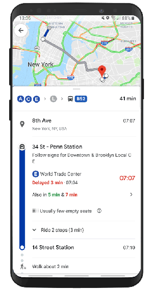
There are two types of transit riders. Those who squeeze on a crammed train and those who wait a few extra minutes for the next train, crossing their fingers it will be less crowded. With the new crowdedness predictions, the latter can now make an informed decision whether to wait out or not rather than relying on luck.
The prediction feature is made with a new prediction technique Google has been perfecting for more than half a year. Starting in October last year, Google began to ask users to rate their journey if they had traveled during the peak commuting hours from 6 am to 10 am. The rating also included questions about how many seats were available or if it was a standing room only, in order to identify which lines had the highest number of crowdedness reports.
Over time, Google was able to turn this data into a prediction tool designed to tell commuters how crowded their bus or train would be. The crowdedness prediction feature is not the first of its kind in Google Maps. Similar features are already showing Google Maps users how busy restaurants and retail locations typically are at different times of the day.
Real-time updates
Google has been offering commuters real-time transit information since December 2017. However, this information is provided by local transit agencies and is not available in all cities. As hundreds of millions of people around the world rely on public transit for their daily commute, and over half of the world's transit trips involve buses, Google has now launched live traffic delays for buses in those markets where the information has been lacking.
With this new feature you’re now able to see if your bus is delayed, how long the delay will be, and more accurate travel time based on live traffic conditions along your route. You can even see exactly where the delays are on the map so you know what to expect before you jump on your bus.
The feature is driven by a machine learning model that combines real-time car traffic with data on bus routes and stops to better predict how long a bus trip will take.
The new features are being rolled out in nearly 200 cities worldwide to both Android and iOS users.
If you don't want to miss out on Google Maps news and inspiring Google Maps use cases, remember to check out our blog or follow us on FaceBook, and we'll keep you updated.


July 2, 2019
.jpg)

