
If you have an asset tracking solution, you’re probably using these Google Maps APIs: The Dynamic Maps and the Geocoding API - like 90% of our customers. This also applies to other industries like fleet management, dispatch and deliveries, and taxi driving, but we’ll get back to that later on.
There’s nothing wrong with using these APIs. Actually, you need them. Together they form the perfect foundation for almost any asset tracking solution. However, they “only” provide you with a map and geographical coordinates. If this is all the data you need, you don’t need to read the rest of this blog. But, if you’re looking for inspiration to take your solution to the next level, now is the time to pay attention.
Google Maps offers an array of different APIs. Some of them, like Dynamic Maps and Geocoding, are well-known and well-used. Others, on the other hand, have not yet gained the same recognition even though they hold immense potential across industries, and these are the APIs we’ll walk you through in this blog post.
The Distance Matrix API
The Distance Matrix API is a service that provides travel distance and time for a matrix of origins and destinations, based on the recommended route between start and end points.
When you use Google Maps Platform to plot multiple locations, you can see markers visually. While this shows you if the locations are close to each or not, it doesn’t provide you with the true distance. To calculate the distance between two locations, you can use the Maps Javascript API, but if you want to determine the distances between many points at once and include real-time traffic information, you need the Distance Matrix API. This makes the API very useful for businesses that need to calculate the distance from multiple origins (e.g. drivers) to one destination (e.g. the customer) or from one origin (e.g. delivery truck) to multiple destinations (e.g. drop-off depot).
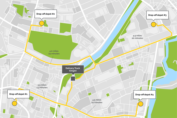
As we talked about in this blog, delivery services in some of the world’s biggest cities promise to deliver your food within 40 minutes. Considering the time it takes to prepare a meal, this leaves drivers with very little time to deliver food. With the Distance Matrix API food deliveries can narrow a list of restaurants by drive time, so customers can only see and order from nearby restaurants.
Speaking of food delivery, the Distance Matrix API also allows you to choose your favorite mode of transportation. For instance, in bigger cities in both Europe and Asia, food delivery is mostly done on bikes or two-wheelers. Chances are, that the best route by car is not the best route by bike or two-wheeler and vice versa. The Distance Matrix API takes this into account, so if your couriers are delivering food by bike, it’ll include bike-friendly routes that may not be accessible by car. Are they delivering food by car on the other hand, these routes will of course not be included in the calculation.
Taxi and ridesharing companies can use the Distance Matrix API to identify the nearest driver (in drive time) to a customer. The API also allows them to provide customers with an estimated time of arrival (ETA). When you’re rushing to get to the airport on time, getting matched to a nearby driver and seeing real-time ETA can mean the difference between making or missing your flight.
Whether you have a food delivery service, a taxi company, or a large fleet to manage, the Distance Matrix API enables you to efficiently utilize your fleet and meet customer expectations. That’s why the Distance Matrix API should be a key component in your mobility solution.
The Directions Advanced API
Directions Advanced is an API, but also more specifically a way to request more detailed information from the API than you get from just the directions API. In this case, Directions Advanced is a request to the Directions API or the Maps JavaScript API’s Directions Service that uses traffic information, more than 10 waypoints, and/or waypoints optimization.
Time is money. No matter your industry, you want your drivers to be moving, not to be stuck in a traffic block. With Directions, Advanced Google Maps provides you and your drivers with real-time traffic information. This means that every time you search for directions to a specific location, Google Maps will show you if there has been an accident or if the traffic is heavy. This allows you to choose an alternative route and avoid delays.
When calculating routes using the Directions API, you may specify waypoints to return a route that includes pass-throughs or stopovers at intermediate locations. Think of delivery services where each driver has to deliver packages to several destinations each day. If a route has more than 10 (11-25) waypoints, you need Directions Advanced. By default, the Directions API calculates your route through the provided waypoints in their given order. However, you can use Directions Advanced to optimize the provided route by rearranging the waypoints in a more efficient order, saving you both time and money.
The Geolocation API
The Geolocation API is a powerful API when tracking equipment - especially in dense urban environments. For most of us, GPS is probably the first thing that comes to mind when talking about location tracking. However, while GPS is, in most cases, very accurate, it has its downsides.
GPS signals travel by line of sight. This means that they will pass through clouds, glass, and plastic, but they won’t pass through most solid objects, such as buildings or mountains. If you’ve ever used a navigation app in a dense urban environment with big buildings on either side of the street, you have probably experienced how the blue dot can flicker around for a while before determining your exact location. The problem is that the signals from the navigation satellites get blocked by these buildings or in some cases bounce off the buildings before they reach your phone. This makes it miscalculate the distance to the satellites and incorrectly triangulate its position. Another downside is how much energy GPS trackers use. A GPS tracker can quickly drain your battery, as it’s constantly receiving signals from the satellites and calculating its position.
The Geolocation API triangulates a location and accuracy radius based on information about cell towers and WiFi nodes that the mobile client can detect. First of all, this ensures very high accuracy thanks to the vast amount of especially WiFi nodes but also cell towers. Second of all, you decide how often you want the Geolocation API to return a location. This means that the batteries in your trackers can potentially last 10 years instead of just 6 months with a GPS tracker.
The Dynamic Street View API
The dynamic Street View API provides an interactive 360-degree view of an area from designated roads, just like the Street View you know from the consumer Google Maps app.
The Dynamic Street API is an excellent and in some cases essential planning tool for all kinds of dispatch and delivery businesses. Thanks to Google Maps, getting from A to B is usually pretty easy as long as you have the address or coordinates of your destination. However, addressing visibility and transparency surprisingly often leaves something to be desired.
With the Dynamic Street View API drivers can explore the ground in advance. This prevents them from wasting time hunting down the right building or door, if the address is not visible. It also makes it easy for them to see if they can park right outside or if they need to find a different place and, in that case, where that place is.
The Snap to Roads API
Just like Hansel and Gretel made a trail of breadcrumbs to find their way out of the woods, GPS trackers leave a crumb every time they update their location. This trail can help you determine the route traveled and create itineraries. However, thanks to the problem of GPS jitter, chances are that the crumbs don’t actually connect to the roads you’ve traveled.
Snap to Roads is one of three services offered by the Roads API. The Roads API allows you to map GPS coordinates to the geometry of the road, and Snap to Roads returns the best-fit road geometry for these coordinates. The way it works is that Snap to Road takes up to 100 GPS points collected along a route, and returns a similar set of data with the points snapped to the most likely roads you were traveling along. Like this, you can easily track your movements and automatically create itineraries or log trips for administration. This saves time for both you and your administration and increases productivity.
April 22, 2020
.jpg)

