
When you think of Google Maps, your first thought is probably not a classroom. However, as technology becomes an increasingly common mode of education, Google Maps offers some particularly interesting tools to teach subjects like history, geography, and politics. There are many creative ways to use what Google has to offer to digitize your classroom and add visualization to your teaching process. Technology gives tools for students and teachers alike making it easier to track progress, research topics, communicate, and facilitate learning.
Google Maps
I remember very clearly having to draw the Iron Curtain on a map when I was in school. Well, you can easily use Google Maps to get your students to build a map of what the world looked like in a given time in history. Draw new frontiers, measure distances, or create points of interests to highlight different events. This can be done on a variety of base maps, including terrain and satellite.
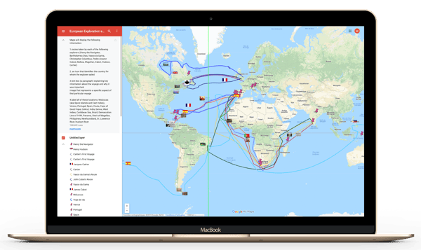
To do so, log in to Google, access ‘My places’ and create a new map. These can be shared and worked on by multiple people, reviewed, and edited. On each map, you can create lines, points of interests that are customizable by color and symbology, adapt the base map, make notes, and of course, save changes and progress.
Google Street View
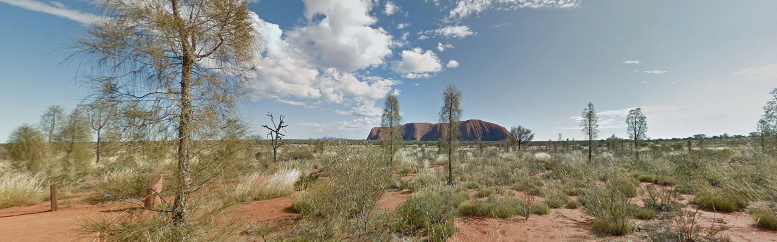
There is so much to see of the world but, as fun as field trips can be, they’re not always feasible. This is where Street View really comes in handy. You can use Street View to immerse your students in a specific location thanks to the 360-degree angles and the capacity to “walk-around” and move within the map.
The gallery on Google’s website gathers a large variety of points of interests by themes or locations. This provides a valuable resource to explore the world from the classroom. For example, the collections ‘This is Home’ and ‘Indigenous Culture Around the World’ are a great tool to discover how other cultures live. Not only do these collections provide a 360-degree view of specific locations, but it also comes with a text that gives information on the place, the building, or the event that happened there. It’s also possible to view the spot on Google Maps to put it back in a geographic context or ‘walk around’. The variety of locations is huge, from the inside of museums to a look into life in space! The search bar makes it easy to find exactly what you are looking for or you can roam around the world.
This can be taken a step further by using virtual reality - which is possible through Google Cardboard, a headset which immerses you in the landscape through Street View.
A final idea on the use of Street View in your classroom is to have a little game! GeoGuessr is a game using Street View that drops you in a random location around the globe, which you have to pinpoint as accurately as possible. It can be played in teams and around specific themes. This blog post thoroughly explains how it works. It is a great way to teach geographic markers like flora, fauna, languages, architecture, and more.
Google Earth
Google Earth works hand in hand with Street View but gives you more freedom with zooming in and out and seeing the bigger picture. Another great feature of Google Earth is Timelapse which shows the same landscape over a span of 35 years, from the mid 80’s to today. Timelapse highlights dramatic changes in urban development, rivers changing their course, glaciers retreating, and deforestation. While the website highlights particularly interesting locations around the world, the search bar lets you search for specific locations around the world.
The Voyager tab in Google Earth has multiple categories including nature, culture, and education. These lead you to a selection of voyagers in which you can discover more about the history of the world. Explorers: Vikings take you through key Viking journeys around the globe by not only showing the routes, but also giving historical facts about each point as well as videos that go deeper into the topic.
To go further you can actually download Google Earth on your desktop for free. This allows access to features such viewing as maps over time, which displays historical imagery or observing how the landscape is affected by the sun throughout the day.
We’re in a digital age and classrooms have to keep up with the use of technology. Rather than taking away from learning, technology can be a great tool to explore and teach in a way that was never available to us before.
If you liked this blog, you'll probably enjoy our blog "How Geoguessr Created a Discovery Game with Google Maps and Street View" too. Click the green button below and get ready to test your geographic skills.

August 14, 2019
.jpg)

